


Sourced Information

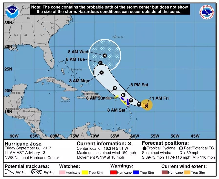
Hurricane Jose is centered at 11 a.m. AST/EDT about 415 miles (670 km) east-southeast of the northern Leeward Islands, moving toward the west-northwest near 18 mph (30 km/h). A gradual turn toward the northwest with a decrease in forward speed is expected during the next 48 hours.
On the forecast track, the center of Jose will pass near or east of the northeastern Leeward Islands on Saturday. Recent data from an Air Force Hurricane Hunter plane indicate that maximum sustained winds are near 150 mph (240 km/h) with higher gusts. Jose is a category 4 hurricane on the Saffir-Simpson Hurricane Wind Scale.

Some fluctuations in intensity are possible for the next day or so, and gradual weakening is expected after that. Hurricane-force winds extend outward up to 35 miles (55 km) from the center and tropical-storm-force winds extend outward up to 115 miles (185 km). The minimum central pressure indicated by data from the aircraft is 942 mb (27.82 inches).
A Hurricane Watch is in effect for Antigua, Barbuda, Anguilla, Sint Maarten, St. Martin and St. Barthelemy. A Tropical Storm Warning is in effect for Antigua, Barbuda, and Anguilla, St. Martin, St. Barthelemy, and Sint Maarten. A Tropical Storm Watch is in effect for Montserrat, St Kitts, Nevis, Saba , St. Eustatius, the British Virgin Islands, St. Thomas and St. John.
For storm information specific to your area in the United States, including possible inland watches and warnings, please monitor products issued by your local National Weather Service forecast office – www.weather.gov For storm information specific to your area outside the United States, please monitor products issued by your national meteorological service.
For more information regarding Jose, go to the NHC website at www.hurricanes.gov